
IIT Bombay FOSSEE Geospatial Mapathon 2026 (Edition VI)
A joint initiative of the Geospatial FOSSEE project, Indian Institute of Technology Bombay, under the aegis of the National Mission on Education through ICT (NMEICT), Ministry of Education, Government of India, and the Rural Data Research and Analysis (RuDRA) Lab
The world's biggest open-source geospatial mapping challenge!
REGISTRATION URL: https://forms.gle/3Phginn1m87kVuSi7
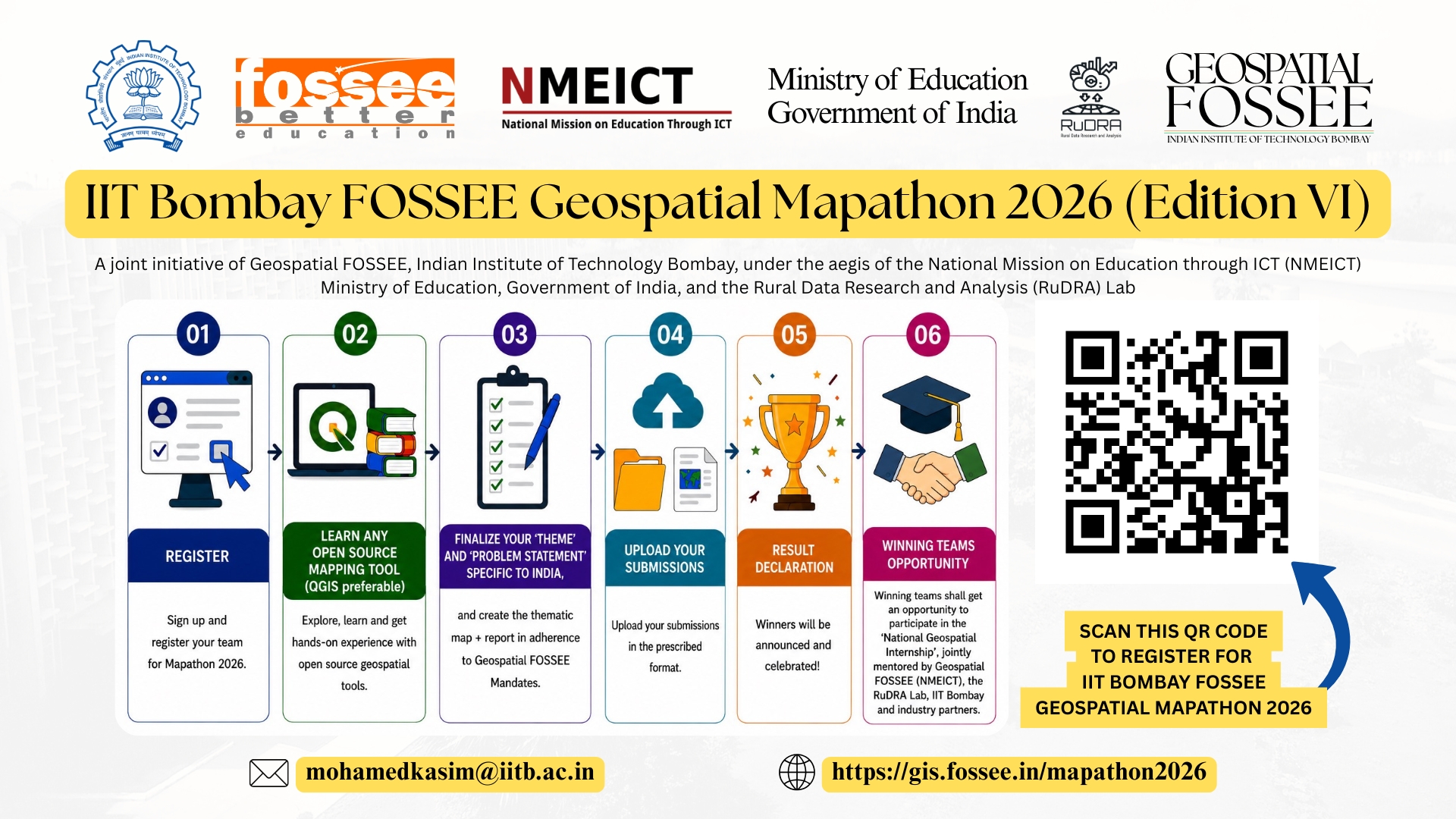
The IIT Bombay FOSSEE Geospatial Mapathon 2026 (Edition VI) is a map-making competition for creating thematic maps, using open-source mapping software and Indian satellite data. It is a collaborative event where participants come together to develop new tools/methods that improve the accuracy and usefulness of maps for a community. The Geospatial FOSSEE project, IIT Bombay, along with the Rural Data Research and Analysis (RuDRA) Lab, invites all eligible citizens of India (Students, Faculty, Researchers, and industry professionals) to participate in this open-source-based geospatial map-making challenge using data specific to the Indian context (e.g., observation data, remote sensing data, crowdsourced data, etc). The primary objective is to understand the potential of remote sensing data and make maps for Indian regions using free open-source mapping software (e.g., QGIS). The participants will collectively work in a crowdsourcing method for jointly producing thematic maps of India. All the Geospatial FOSSEE activities are organized under the aegis of the National Mission on Education through ICT (NMEICT), Ministry of Education, Government of India, aligned with the National Geospatial Policy 2022, Indian Space Policy 2023, and National Education Policy 2020.
The data collected from various platforms has tremendous potential in mapping India’s resources, agriculture, climate, and disaster management, rural and urban planning, and in identifying pathways for future development. Such maps can be created using free open-source platforms (such as QGIS). Let us join together to create such maps through the Mapathon. The IIT Bombay FOSSEE Geospatial Mapathon 2026 (Edition VI) also aims to develop indigenous capacity to customize and employ mapping to resolve societal challenges and create new opportunities for young India, contributing towards #Atmanirbhar and #ViksitBharat2047.
The winning teams of the IIT Bombay FOSSEE Geospatial Mapathon 2026 (Edition VI) shall be eligible to participate in the coveted, 'National Geospatial Internship,' which is a joint initiative of the Geospatial FOSSEE, Indian Institute of Technology Bombay, the Rural Data Research and Analysis (RuDRA) Lab, and partner institutions.
Opportunity for Everyone!
FOSSEE GIS/Geospatial FOSSEE, Indian Institute of Technology Bombay, provides unrestricted access to institutions that have implemented NEP2020, with a plethora of opportunities with multiple entry/ exit options in the internship (for eligible candidates), open source geospatial curriculum design, faculty development, technical support in setting up an Open Source GIS lab, etc. All that the institution has to do is to subscribe itself and become FOSSEE’s Open Source Geospatial Knowledge Centre (OSGKC), more details are given below. The FOSSEE GIS/Geospatial FOSSEE project, IIT Bombay, aims to create better opportunities for everyone (students, faculty, administrators, policymakers, etc) from diverse educational backgrounds interested in the field of geospatial science and technology.
IMPORTANT DATES
| IIT Bombay FOSSEE Geospatial Mapathon 2026 (Edition VI) | Dates* | Organizer/Resource Person | Venue | Mode | URL |
Registration opens | 01 July 2026 | - | - | Online (livecast from IIT Bombay) | |
| Last date to Register | 16 August 2026 | ||||
Orientation session | 10 July 2026 | Prof. Pennan Chinnasamy Mohamed Kasim Khan M | IIT Bombay | Online (livecast from IIT Bombay) | |
| Workshop on Free and Open Source Technologies | TBD | - | TBD | ||
| Workshop on Open Source Geospatial Map Making | TBD | - | TBD | ||
| State-specific awareness sessions (interested Institutions desiring to host can invite us (logistics to be be covered by the hosting institutions) | |||||
| Doubt-clearing session | 10 August 2026 | - | TBD | ||
Submission deadline | 16 August 2026 | - | TBD | ||
Final Result Declaration | 01 September 2026 | TBD* | Hybrid (Livecast stream) |
Focused Themes
| #Agriculture | #Hydrology |
| #Architechture | Civil Engineering |
| Case Study with #Policy Impacts | #Oceanography |
| #Forestry | #Gaming |
| #RemoteSensing | #Landscaping |
| Geology | #Geostatistics |
| #Groundwater | GIS in Medical Sciences |
| #Transport | #City #Planning |
| #Space | #Glacier |
| #Internet-based Case Study | Land Use Land Cover of Districts in India |
| #Media GIS Case Study | #Medicine |
| #Environmental | #Municipal GIS Case Study |
| #Urban GIS Case Study | #Mining GIS Case Study |
| #Refineries in India | Automobile GIS Case Study |
| #Nautical GIS Case Study | #Ocean GIS Case Study |
| #Oil & #Gas GIS Case Study (#Energy) | Park GIS Case Study |
| #Government GIS Case Study | Real Estate GIS Case Study |
| Societal GIS Case Study | Soil GIS Case Study |
| #Sports GIS Case Study | #Geodesy GIS Case Study |
| #Telecommunication GIS Case Study | #Tourism GIS Case Study |
| Transmission GIS Case Study | Spatial Billing Systems |
| Street view measure | #Weather GIS Case Study |
| #SmartCity | #SmartVillage |
Problem Statements (Sample)
Mapping of natural resources/man-made features
Natural Resources Change Detection
LULC Change with hotspots using LULC maps from Bhuvan
Flood Maps
State-wise Health Care Indicators Maps
Locust infestation / Stubble burning / Low lying areas / Low lying areas / Jhum Cultivation
Road Network and Road Quality / Drainage Maps
Land Degradation Maps
Health infra, population, age group, etc. for Vaccination
Detection of change in Waterbodies / Reservoirs / Wetlands
Crop / Plantation type map
Amenities map
Water source and quality mapping
Population crowding/ traffic hotspots
Network coverage maps
Local markets/produce/employment maps
Map of waste segregation and collection points
Mapping places of cultural importance
Choose your own topic
Geospatial FOSSEE Mandates
To participate in any of the FOSSEE GIS activities, the participating individual/team(s)/Institutions must follow the mandates as listed below:
- Indian Citizens Only.
- The participant(s) must be a bona fide students/faculty/staff of the institution recognized by UGC/AICTE/AIU or a body recognized by the Union and/or State Government.
- Use only Free/Libre Open Source Software/Open Source Hardware.
- Activity must align with at least one SDG (UNDP).
- Study area should be India-specific.
- Work on real-life data sets based on the Indian context.
- Datasets must be “non-sensitive” and from a “genuine/valid source”.
- Adhere to the (Indian) National Geospatial Policy 2022 and Indian Space Policy 2023.
- Use shapefiles from the Survey of India Portal ONLY.
- Use Indian satellite data from ISRO-NRSC’s MOSDAC, Bhuvan, Vedas, Bhoonidhi portals, and indigenous Indian technologies like NavIC, etc.
- Problem statements can be inclined toward the PM Gati Shakti Portal (recommended).
- The qualified entries of all IIT Bombay FOSSEE GIS (NMEICT) initiatives shall be released under the Creative Commons (CC-BY-SA or related) license.
Core Team
Prof. Prabhu Ramachandran
Principal Investigator, FOSSEE project, Department of Aerospace Engineering, Indian Institute of Technology Bombay
Prof. Pennan Chinnasamy
Co.Principal Investigator, FOSSEE project/ Overall Lead - Geospatial FOSSEE, Prof-in-Charge, The Rural Data Research and Analysis (RuDRA) Lab, Indian Institute of Technology Bombay
Mohamed Kasim Khan M <mohamedkasim@iitb.ac.in>
Coordinator - IIT Bombay FOSSEE Geospatial Mapathon 2026 (Edition VI); National Coordinator - Geospatial FOSSEE & Senior Research Scientist (NMEICT), Department of Aerospace Engineering, Indian Institute of Technology Bombay.
Scientists and Researchers from the Rural Data Research and Analysis (RuDRA) Lab, Indian Institute of Technology Bombay
#India #IIT #IITBombay #Geospatial #Mapathon #NMEICT #MinistryofEducation #GovernmentofIndia #ISRO #NRSC #NASA #Space #Application #Internship #Hydrology #Agriculture #Water #Climate #Science #Engineering #GIS #Map #NGP2022 #ISP2023 #Policy #Urban #Planning #Rural #Development #Student #Faculty #Academia #Research #UGC #AICTE #University #College #Irrigation #Mining #LULC #CivilEngineering #OpenSource #FOSS #FOSSEE #PennanChinnasamy #MohamedKasimKhan